
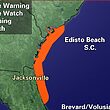


Hurricane Irma is hundreds of miles away from coastal South Carolina, but that doesn’t mean the storm’s impact won’t be felt in the area.
What some people might be asking is why this storm is such a big deal.
To start with, this is a huge storm. It’s the second Category 4 storm to make landfall within the same hurricane season as another Category 4 storm (with Hurricane Harvey being the first of which this season). What makes it even more interesting is that these two storms happened or are happening consecutively.
As of Sept. 10, Irma is blasting Florida with 135 mph winds and intense flooding. According to the National Hurricane Center Project, Irma is moving northwest along the Florida Gulf Coast. That means the storm itself is very far from South Carolina, but that doesn’t mean the storm will have no impact.
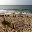
On Sept. 11, Irma’s impact will hit the Lowcountry. As of right now, the storm is creating gusty winds and a deep low pressure over the area. This wind and pressure will continue to intensify, which means the Lowcountry area will likely experience tropical-storm force winds, the strongest of which will be on the beach.
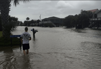
Heavy rainfall will accompany this wind and could cause downed trees and power lines. Due to the saturation level of the soil at present, flooding is almost certain to some degree in most areas.
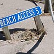
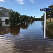
Major coastal flooding is also expected during high tide as waters rise. The flooding should begin within one to two hours of high tide and could last for several hours after the peak of the tide. The causeway, side roads, and Palmetto Boulevard are likely to experience standing water. Remember, do not attempt to drive through water as it could be dangerously deep and contain a strong current.
This flooding will be particularly dangerous in Charleston as the high water levels will put much of The Battery and the surrounding area under water.
What’s interesting about Irma is that unlike Hurricane Matthew, which caused quite a bit of flooding and damage, this storm’s wind pattern is different. With Matthew, the storm track blew winds offshore, which helped reduce the surge. This storm is blowing the winds onshore, which is going to cause an intense storm surge.
Bear in mind that the storm surge does not just impact those right along the coast. Inland rivers and creeks in the tidal zones will also experience significant flooding.
Again, remember that while Irma is far from the Lowcountry, anyone in this area is not yet out of the woods. Until the storm has passed and evacuation orders are lifted, it is important for anyone in the area to refrain from going outdoors or traveling.
The storm is also likely to generate tornadoes throughout the area. If so, be sure to go to a central room and stay away from windows.
To stay abreast of the latest storm information, allow for wireless emergency alerts on cellular phones and/or tune into broadcasts from the National Oceanic and Atmospheric Administration (NOAA). These broadcasts will help provide listeners with the latest updates. Their dedicated Irma page can be found online here: www.nhc.noaa.gov/#irma